

Heritage mapping
The New Forest has a rich and varied history of human interaction extending back at least 13,000 years. This evidence can still be found within the National Park boundary and has been influential in shaping the landscape we see today. It is this legacy from the past that helps make the National Park such a special place.
The New Forest National Park Authority has a duty to conserve and enhance this historic environment for everybody. Although there has been a long and continuing local tradition of archaeological and historical research, some aspects of the National Park’s archaeology have seen less research and investigation compared to other areas of the country.
The number of new sites found in current archaeological surveys in the New Forest suggests that there could be many thousands of undiscovered sites and landscape features still to be recorded in the National Park.
Read on to find out how exciting laser scanning technology from an aircraft called Lidar (Light Detection And Ranging) is helping us to care for the New Forest’s historic environment.
What is Lidar?
Interpreting the ‘lumps and bumps’ on the landscape can tell us a lot about how the New Forest has been used and exploited since the Neolithic period.
Finding and recording archaeological features through traditional field survey can be difficult and time-consuming for archaeologists: using such techniques it is estimated that it might be more than 100 years before we have an understanding of the number and range of sites.
Airborne Lidar (Light Detection and Ranging) makes it possible to speed up the process. It is a remote sensing technique that allows a very detailed digital surface model of entire landscapes to be constructed.
A pulsed laser beam is scanned from side to side from a plane as it travels over the terrain, recording thousands of three dimensional points to the ground every second. These pulses reflect off the ground and are received by detectors on the plane, which calculate the distance between the plane and the ground using the known speed of light coupled with the accurate positioning of the plane.
It is possible to gather millions of these exceptionally accurate measurements that can then be processed to create a surface that is an accurate model of the landscape.
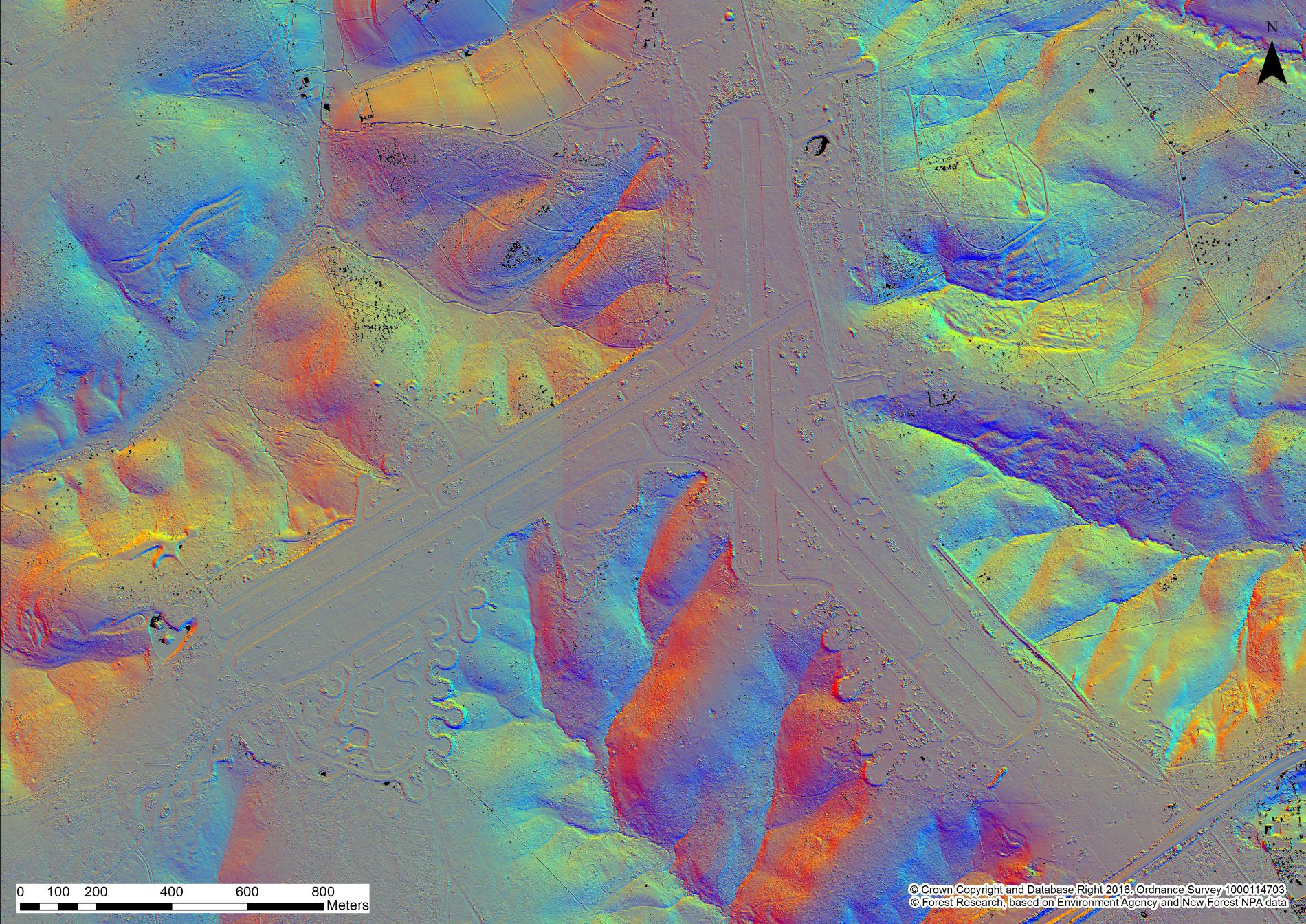
How is Lidar used in the New Forest?
Traditional archaeological survey is often difficult in woodland as vegetation makes sites impossible to reach, see and record. Lidar’s ability to ‘see through’ vegetation is one of its main strengths.
Because the laser pulses can filter between the leaves and branches of trees, we are able to strip away the vegetation and look at the ground – and the archaeology beneath the tree canopy – often with spectacular results.
We can also digitally manipulate the Lidar to produce a range of images by illuminating the model in different ways, examining slope and aspect, viewing in 3D and drawing sections across the landscape.
We can also combine the Lidar with other information, such as historic mapping dating back to the 18th century, aerial photography, near infrared imagery and records of known archaeological sites.
All of these techniques help us to accurately identify and interpret sites, which can then be checked on the ground.
Lidar can be used to identify veteran trees which are of great ecological and historical significance. In processing the Lidar it is possible to remove the landscape to leave just the trees. These can be examined to identify trees of a desired height, form and crown width to isolate potential veteran tree candidates.
Combined with near infrared imagery and aerial photography we can even focus on particular species. Similar processes can be used to monitor scrub growth or erosion and identify particular habitats.
Lidar provides valuable information for land management, grazing schemes and stream restoration projects and also helps to identify ‘palaeochannels’ (the remnants of old river systems).
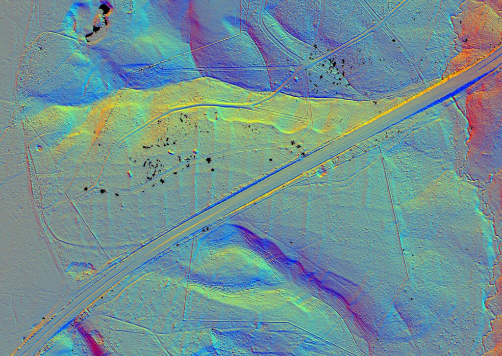
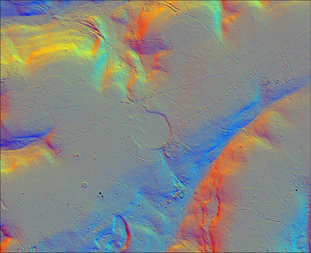
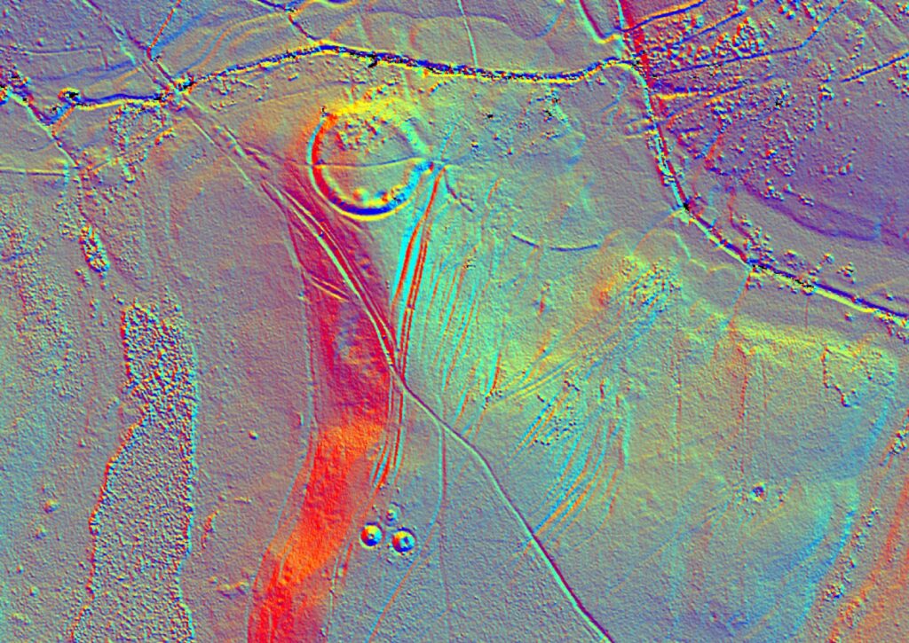
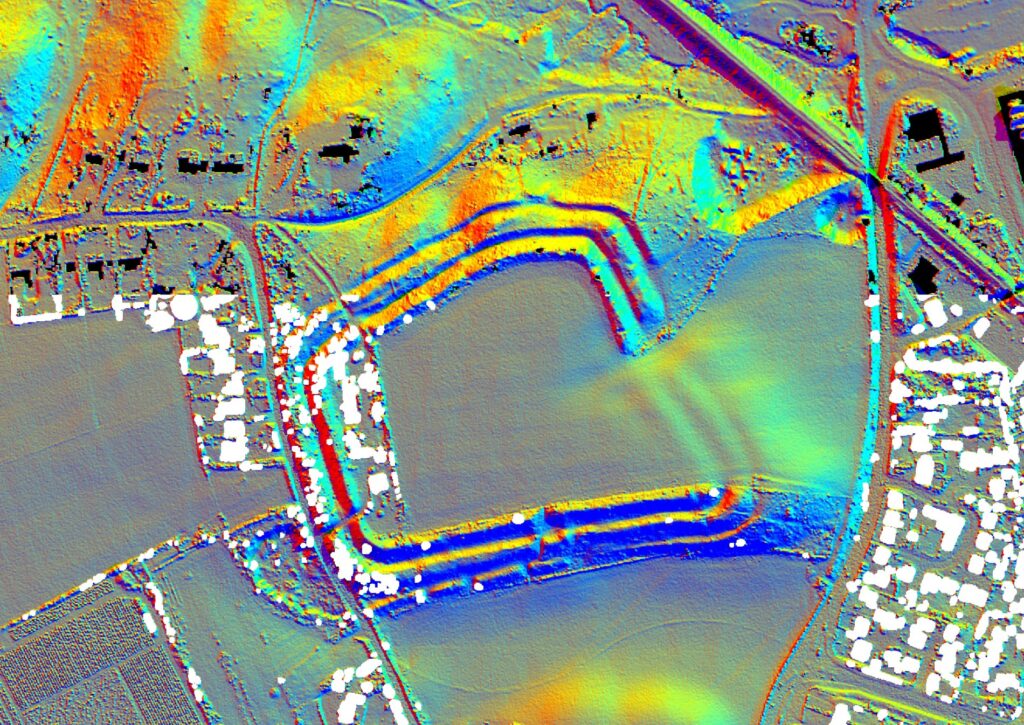
Interpreting lidar
This image shows how some of the landscape features seen throughout the New Forest appear within the Lidar data.
The dappled areas show how the laser beam can penetrate through the tree canopy. However very dense woodland and areas of evergreen, such as holly or rhododendron, can cause problems within the recording, where the laser beam cannot penetrate the canopy.
Also, due to the way the Lidar is processed, features recorded over a certain height are removed for the data as ‘non-archaeological’ and this is why structures and buildings often appear within the data as black squares.
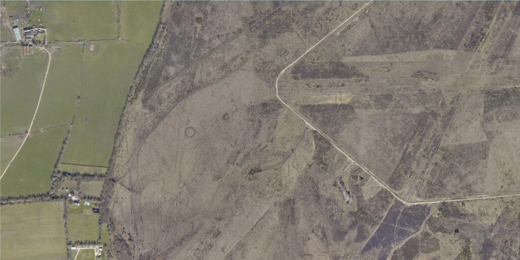
Explore aerial photography
Through laser mapping surveys we also recorded high resolution aerial imagery to help support the features seen in the Lidar data.
Unlike web services such as Google Earth which use satellite imagery, these images were captured from an aeroplane and recording was undertaken during the winter months so that there was less leaf cover on the trees.
The imagery can be used to identify earth works, crop marks and parch marks all associated with archaeological remains. The data can also be used to help record ecological changes within woodlands and heathland.
Explore laser mapping
The Lidar data is gathered through the use of a laser scanner recording 3D points during a flight over the landscape. Both the Lidar maps and Lidar zoom pages show a combination of hill shade analysis of this raw Lidar data.
By creating artificial light sources on the landscape (azimuths) on a computer, the data can show where shadows would be created by the lumps and bumps seen on the earth’s surface.
Although buried archaeological features cannot be identified, anything seen breaking the ground surface or above it do show up.
Explore near infared mapping
Near infrared records a band of light not visible with the human eye. It has been captured using an infrared camera during Lidar flights.
The camera looks at a different spectrum of light to that which we normally see with the naked eye.
Differing moisture levels, ground density and varying vegetation coverage seen on the earth’s surface absorb this light in different ways, and this variation can be used to identify archaeological and environmental features.
Lidar and the Higher Level Stewardship scheme
The Lidar project is funded as part of the New Forest Higher Level Stewardship scheme. One of the aims of the HLS scheme is to encourage responsible land management that will help to preserve and enhance the environment, including the archaeology within it.
Lidar is an incredibly powerful tool in helping to manage the Forest landscape and identify archaeological sites.