Explore laser map
In its most basic form, 3D Lidar data allows us to create a detailed model of the earth’s surface within the New Forest National Park. The data also allows us to remove any tree cover seen throughout the forest and look at the topographical changes seen beneath the trees.
The Lidar data is gathered through the use of a laser scanner recording 3D points during a flight over the landscape. Both the Lidar maps and Lidar zoom pages show a combination of hill shade analysis of this raw Lidar data.
View the tiled Lidar map of the National Park
By creating artificial light sources on the landscape (azimuths) on a computer, the data can show where shadows would be created by the lumps and bumps seen on the earth’s surface.
Although buried archaeological features cannot be identified, anything seen breaking the ground surface or above it do show up.
View the zoom Lidar map of the National Park.
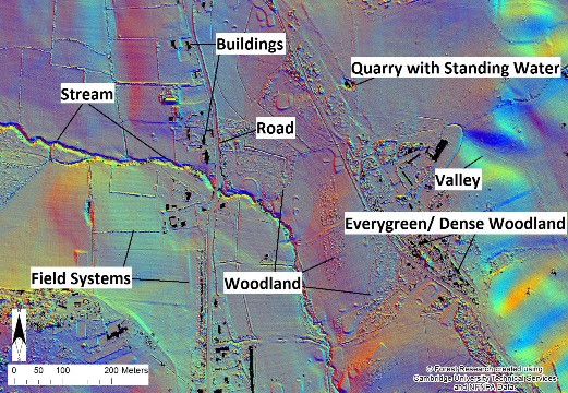
Interpreting Lidar
The image below shows how some of the landscape features seen throughout the New Forest appear within the Lidar data.
The dappled areas marked as woodland shows how the laser beam can penetrate through the tree canopy. However very dense woodland and areas of evergreen, such as holly or rhododendron, can cause problems within the recording, where the laser beam cannot penetrate the canopy.
Also, due to the way the Lidar is processed, features recorded over a certain height are removed for the data as ‘non-archaeological’ and this is why structures and buildings often appear within the data as black squares.
You can look out for these types of features labelled below: